This article is more than
3 year oldHurricane Ian barreled into the southwest Florida coast Wednesday as a Category 4 monster just miles from where the National Hurricane Center initially projected it could hit.
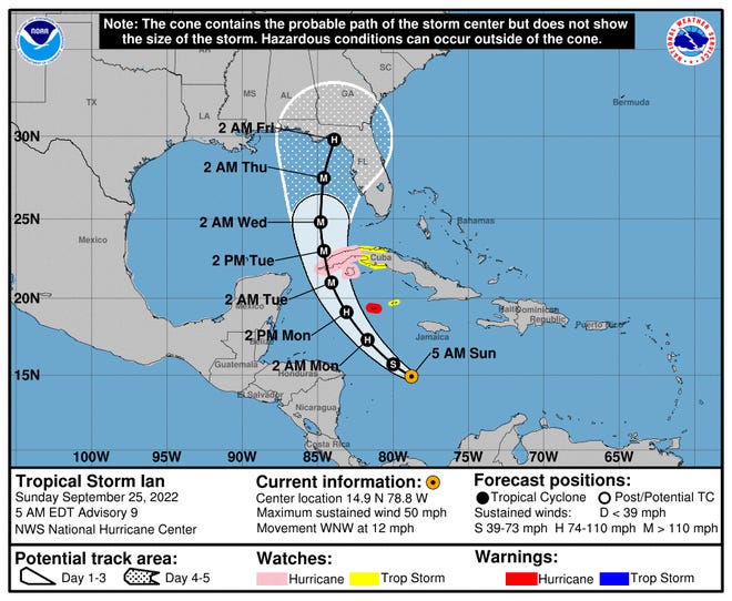
In the days leading up to landfall, the forecast shifted the center of the track as far north as Florida’s Big Bend on Sunday and also hovered over Tampa Bay on Sunday and Monday. The potential track forecast ignited fears the densely populated Tampa and St. Petersburg area could get its first direct hit since a 1921 hurricane.
Ultimately, Ian made landfall more than 100 miles to the south, very near the first position estimate for a potential Florida landfall.

So were the weekend forecasts wrong?
“If we look at the forecast track of Ian with the 5-day cone, its soon-to-be landfall point was pretty much always in the forecast cone, just right on the edge,” said Phil Klotzbach, a tropical meteorologist at Colorado State University and lead author of its seasonal hurricane outlooks.


It’s the area where the center of the storm is most likely to move over five days, said meteorologist Scott Spratt, who retired in December as a warning coordinator for the National Weather Service office in Melbourne, Florida.
“It’s a great snapshot that shows you every six hours where your geographic location is relative to the cone,” Spratt said. “It allows people to see the trends and prepare.”
More::Hurricane Ian nears Florida threatening storm surge. Graphics explain the deadly weather event.It does not indicate where all the storm impacts will be, or even guarantee the center of the storm will stay within the cone.
“NHC forecasters have been very consistent with advertising that the uncertainty in the track forecast was larger than normal,” Klotzbach said. “It was a complicated mess of an upper-trough over the western Gulf of Mexico, a ridge building into the Midwest, a trough over the East Coast, as well as the strength of Ian.”
Ian tended to track slightly faster than anticipated by the forecast models, he said.
It’s important for people to understand the uncertainties in the forecasts, said James Franklin, a retired hurricane specialist who wrote many forecasts for the hurricane center. That’s the point of the cone.
The track shifted west and northward over the weekend because forecasters couldn’t say for sure how Ian would react to those other influences in the Gulf, Franklin said.
“I think the track forecast numbers for (Ian) are going to be pretty good by historical standards,” Franklin said. “But again when you have a storm making an approach at an oblique angle to the coast like Charley did, and like Ian is doing, it doesn’t take very large track errors to make a big difference as to where those impacts are going to occur.”
“It’s a good illustration of where we are with uncertainty in track forecasts,” he said. “They’ve gotten better but they’re not perfect yet.”
The size of today’s cone shows the vast improvements in track forecasts over four decades. Between 1990 and 2020, the two-day track forecast error dropped from roughly 200 nautical miles to about 50 miles, Franklin said. "The 72-hour errors dropped from 300 nautical miles on average to 75."
“Since Hurricane Charley (2004) the 48-hour error has been cut in half,” from 120 nautical miles to 50, Franklin said. In 2004, the 5-day error was about 300 miles and now it’s about 150.”
Because the cone keeps getting progressively smaller as track forecasts improve, and the size of tropical storms remains the same, more tropical storm impacts are expected outside the cone than ever before.
The fluctuations in Ian’s forecast path are a good lesson that at two or three days out, it doesn’t make sense to focus too sharply on any one community, especially on a coast where hurricanes arrive at oblique angles, Franklin said.
Klotzbach also noted that because Ian was tracking parallel to the coast slight changes "make big differences in who ends up getting the biggest impacts."
Anyone in the cone should not be surprised to see shifts and should be prepared, not putting up shutters or evacuating necessarily, but to “be aware so they’re not caught off guard or surprised," Spratt said.
Both he and Franklin said confusion about track shifts often arise when people focus on individual computer models or forecasts from independent or amateur forecasters.
“They’re making their own forecasts or forecasts based on one model,” Spratt said. “That makes a difference in people’s minds, and they may think they’re out of danger.”