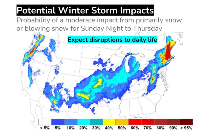
Storms set to sock Eastern U.S., Midwest: ‘Expect disruptions to daily life’
The first of a pair of storms should arrive Saturday and is expected to drop a swath of plowable inland snow near the East Coast. Then a new major winter storm is forecast to charge across the central and eastern United States between late Monday and Wednesday, with blizzard conditions possible along its western flank.
Winter storm watches for the weekend stretch from the mountains of North Carolina north through southern Maine, affecting over 20 million people. Up to a foot of snow is expected in interior southern New England.
Then the second storm should start taking shape by Tuesday and should track about 200 miles farther west than its predecessor. That means the East Coast will be on the storm’s warm and wet side. At least one to two inches of rain will combine with melting snow and saturated soils from previous wet weather to lead to flooding.
On the cold side of the storm, a blizzard — one with heavy snow, strong winds and whiteout conditions — is looking increasingly probable. Chicago, St. Louis, Kansas City and Indianapolis will all have to closely monitor the system’s evolution in the days ahead as — depending on the storm’s exact track — they could find themselves contending with blizzard conditions.
On the storm’s south side, near the Gulf Coast, severe thunderstorms and tornadoes are possible, particularly late Monday through Tuesday.
“Expect disruptions to daily life,” the National Weather Service wrote, concerning next week’s storm.
The pair of storms is part of a larger picture of meteorological mayhem poised to leave few areas of the Lower 48 states untouched over the next 7 to 10 days. Once these two storms pass, an intense blast of cold air and additional storminess could sweep over much of the western and central United States heading into the Martin Luther King Jr. holiday weekend.
System 1: a Mid-Atlantic and Northeast winter storm
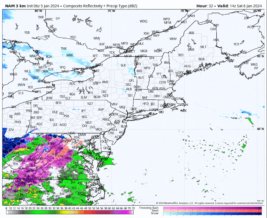
A winter storm — but not necessarily a snowstorm — is less than a day away from the East Coast. Close to the coast, mainly rain should fall in Washington, Baltimore, Philadelphia and New York City. Temperatures are simply too warm for more than a sloppy wintry mix that flips to rain in the coastal plain from the Mid-Atlantic into southern parts of the Northeast.
Around Washington, Baltimore and Philadelphia, the chance of snow has nearly evaporated; mostly rain is now forecast after perhaps a very brief period of mixed precipitation. New York City will walk a snowfall tightrope. The National Weather Service is forecasting an inch of slushy accumulation in the city proper.
Into southern New England, enough cold air is expected to filter southward for more snow closer to the coast. The Weather Service is forecasting 4 to 7 inches for Boston, which is under a winter storm watch, but amounts will increase markedly about 50 miles inland, where totals could reach the double digits.
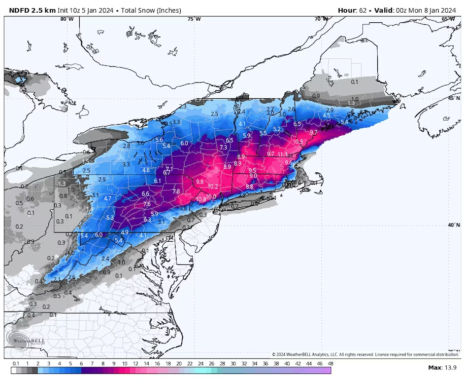
Because the snow will be heavy and wet from northeast Pennsylvania into portions of southern New England and winds could gust up to 30 to 40 mph, the Weather Service is cautioning that power outages are possible.
Confidence in substantial snowfall is highest in the Appalachians. A general 4 to 8 inches is expected from the Virginia-West Virginia border north toward the high terrain of southern Vermont and New Hampshire. In parts of the Worcester Hills of Massachusetts, up to a foot isn’t out of the question. The same is true in east slopes of the Catskills toward the southern Hudson Valley of New York.
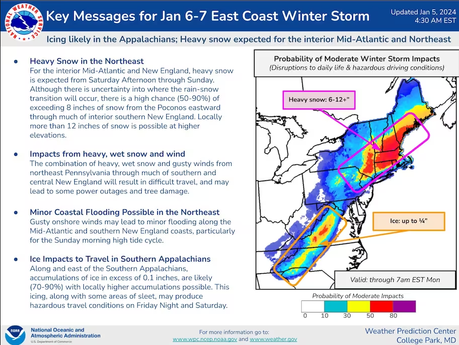
Weather models also indicate some freezing rain may deposit up to a quarter inch of glaze west of the Blue Ridge in Virginia. That could affect Interstates 81 and 68 as far north as the Panhandle of Maryland. At least some freezing rain, snow and sleet will fall as far south as the North Carolina/Tennessee border in the mountains.
The storm will move swiftly at first and is expected to arrive in southwest Virginia early Saturday morning and in New England by evening. Precipitation should end quickly in the Mid-Atlantic on Saturday afternoon and evening. But the storm will likely slow down some off the coast of New England, allowing snow to linger around Boston until around Sunday evening and not pulling away from eastern Maine until Sunday night.
System 2: Potential Midwest blizzard and East Coast flood risk
Confidence is increasing in the potential for a significant and very large storm system to blast the central and eastern U.S. next week. “The winds associated with this system will be unusually strong,” the Weather Service is warning.
On its cold side from parts of the Midwest into the Great Lakes, blizzard conditions could be in the offing. On the warm side, severe weather and tornadoes could threaten parts of the Gulf Coast and Deep South with heavy rainfall and strong winds surging up the East Coast.
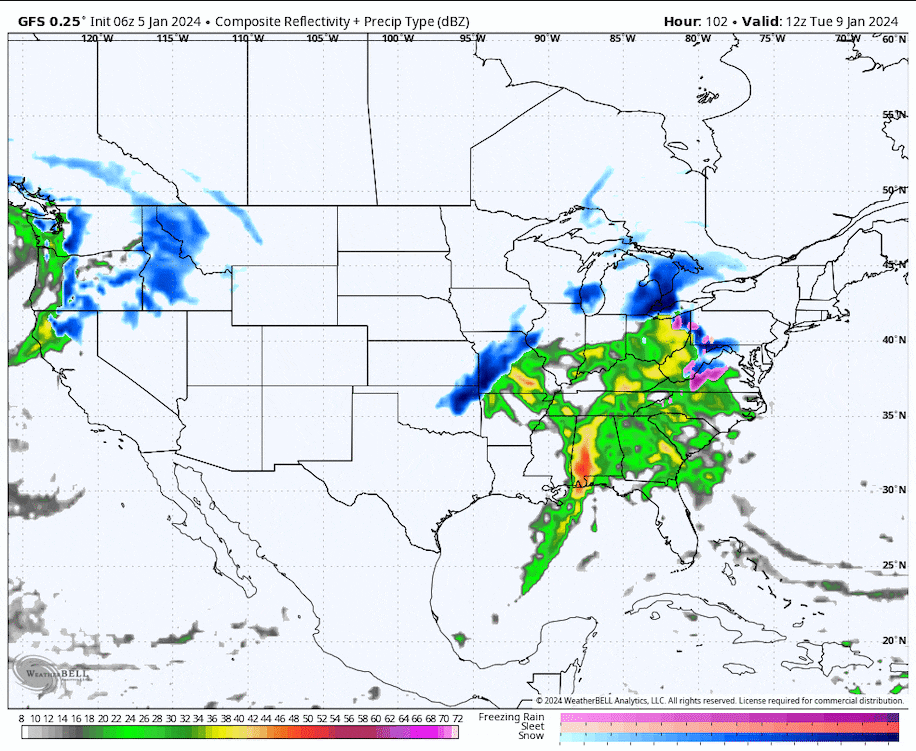
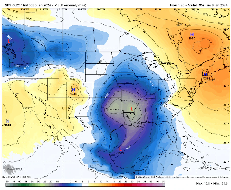
The system is forecast to materialize over southeast Oklahoma or East Texas on Monday afternoon. It will likely intensify as it shifts up the Mississippi Valley, becoming a strong cyclone by the time it reaches the Midwest between Tuesday night and Wednesday. It should eventually move over Lakes Erie and Ontario and into Quebec.
Moisture pinwheeling northwest into the system’s cold side is forecast to deposit a strip of snow from Oklahoma and Missouri to Michigan, and perhaps into Canada as well. Snow totals between 6 and 12 inches are possible. It will probably come in multiple waves, with one pulse of moisture Monday into Tuesday from Kansas to Minnesota and another Tuesday into Wednesday from Missouri to Michigan.
Major airport hubs could be affected. It’s too early to call out specific locations in line for jackpot totals, since another four days remain before the onset of the worst conditions; the predicted placement of the heavier accumulations will inevitably wobble west and east until then.
Cities that could see at least a few inches of snow include Wichita, Des Moines, Minneapolis, Kansas City, St. Louis, Chicago, Milwaukee, Indianapolis and Detroit.
Strong winds will likely also make for blizzard conditions, with gusts of 30 to 40 mph combining with snowfall west of the low pressure’s center. That will come as frigid air swirls into the system.
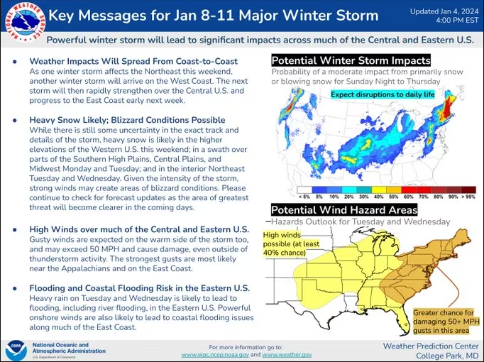
On the storm’s south side, the Weather Service’s Storm Prediction Center cautions that severe thunderstorms could erupt late Monday through Tuesday. The threat for storms on Monday will be highest along the Gulf Coast from roughly Houston to Mobile, Ala. On Tuesday, the threat will likely shift from Florida to the eastern Carolinas.
“The environment may become conducive to considerable organized severe thunderstorm development, including supercells, with potential to produce damaging wind gusts and a few strong tornadoes,” the Storm Prediction Center warned.
That same storm is expected to swirl a tongue of mild air up the Eastern Seaboard, which will melt snow dumped by the weekend storm. It could also drop at least 1 to 2 inches of rain. The rain and melted snow, atop wet conditions because of multiple storms in December, will likely cause flooding.
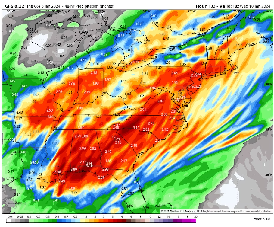
High winds in the Appalachians and along the East Coast are also a concern. As those strong winds drive ocean water toward the shore, coastal flooding is another possibility. The storm could bear resemblance to one in the East the week before Christmas, which caused river and coastal flooding and widespread power outages because of high winds.
After this storm, computer models project not only an outbreak of cold weather in the western and central United States but also the likelihood of two more winter storms sweeping from southwest to northeast between Thursday and the MLK holiday.
Jason Samenow contributed to this report.
Keywords


<p>Chinese officials say they "firmly oppose" the platform being divested.</p>
Ukraine ‘will have a chance at victory’ with new US aid, Zelenskyy says
Congress passes bill that could ban TikTok after years of false starts
Ukraine war: Kyiv uses longer-range US missiles for first time
How soon could US ban TikTok after Congress approved bill?
TikTok faces US ban as bill set to be signed by Biden
‘LOSING CREDIBILITY’: Judge explodes at Trump lawyers as case heats up
Claim rapper ‘made staff watch her have sex’
KANYE WEST PLANS TO LAUNCH 'YEEZY PORN' ... Could Be Coming Soon!!!
Trump lawyer tells SCOTUS that president could have immunity after ordering military to assassinate a political rival