This article is more than
8 year oldHurricane Matthew: Category Four storm pounds Haiti
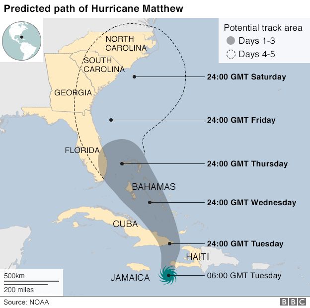
Hurricane Matthew, a Category Four storm, made landfall at the south-western tip at about 11:00 GMT.
The US National Hurricane Center (NHC) said Haiti was "getting everything a major hurricane can throw at them".
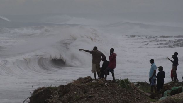
Reports from the southern coast spoke of communities under water and buildings stripped of roofs.
Marie Alta Jean-Baptiste, director of the country's Civil Protection Agency, told Associated Press: "It's much too early to know how bad things are but we do know there are a lot of houses that have been destroyed or damaged in the south."
One resident too ill to leave their home was killed when waves struck in the town of Port Salut.
Haiti's Interim President Jocelerme Privert said earlier that some people at sea or who had not "respected alerts" had died, but he gave no more details.
Haiti is one of the world's poorest countries and many of its residents live in areas prone to flooding. Matthew is expected to bring up to 40in (102cm) of rain to some parts as it moves north at about 15km/h.
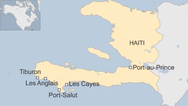
Social media footage from the southern coastal town of Les Cayes showed palm trees being bent sideways and buildings with roofs sheared off.
American journalist Jacqueline Charles told the BBC from the capital, Port-au-Prince, that reports from Les Cayes spoke of people walking in water shoulder high, with relief workers saying that other coastal communities were also under water.
Media player help
Out of media player. Press enter to return or tab to continue.
Fonie Pierre, director of Catholic Relief Services for Les Cayes, told AP: "Many people are now asking for help, but it's too late because there is no way to go evacuate them."
The mayor of Les Cayes, Jean Gabriel Fortune, posted tweets that included video showing damage in the Vernet area.
Nick Bryant, BBC News, Jimani border crossing, Haiti
Haiti has been taking a brutal pounding. The conditions here are atrocious - to step outside is to be drenched within seconds.
Most vulnerable have been those who inhabit the shacks along the western coastline. There, storm surges are the main danger.
People here are confronting life-threatening flooding and the likelihood of mudslides in a landscape denuded of trees.
This Category Four storm comes as this impoverished country is still recovering from the 2010 earthquake which killed more than 200,000 people, and a cholera epidemic that followed.
Many live in shanty towns that offer little protection from the high winds and rains. And many refused to evacuate, fearing that what few possessions they have left would be stolen.
A major road was swamped in Les Anglais, while the mayor of Tiburon, Remiza Denize, spoke of large waves hitting the town.
"Everyone is trying to find a safe place to protect themselves."
Guantanamo Bay evacuation
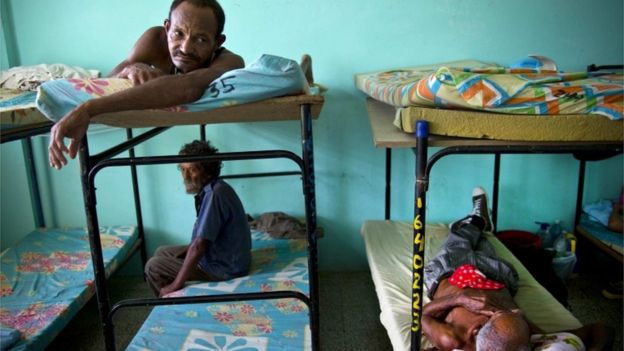
Haitian officials say that about 1,300 emergency shelters have been built, enough to accommodate 340,000 people. Both airports in Haiti are closed.
Media player help
Out of media player. Press enter to return or tab to continue.
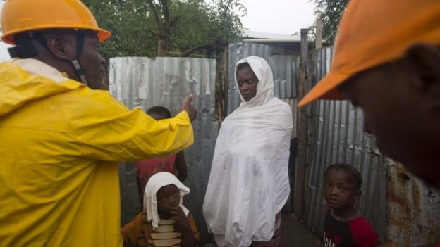
Haitian authorities tried to persuade people to evacuate their homes
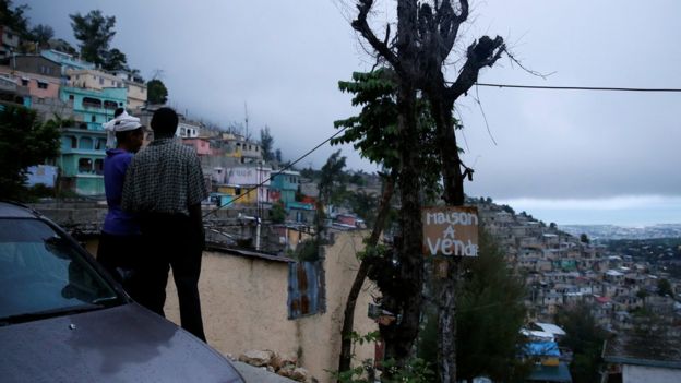
Many Haitians live in flimsy huts vulnerable to flooding. The sign reads "house for sale"
One local in Port-au-Prince said the community would unite in the face of the storm's danger.
"We are communicating amongst ourselves thanks to our own means. We will tell the people how the situation is. If things are bad then we will come together."
Unicef said more than four million children might be exposed to hurricane damage.
The UN children's fund representative in Haiti, Marc Vincent, said: "Waterborne diseases are the first threat to children in similar situations - our first priority is to make sure children have enough safe water."
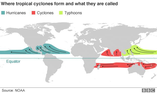
Jamaica too has been feeling the effects of Hurricane Matthew
Parts of Cuba are also on alert
An NHC statement said: "On the forecast track, the eye of Matthew will move near eastern Cuba later [on Tuesday], and move near or over portions of the south-eastern and central Bahamas [on Tuesday night] and Wednesday, and approach the north-western Bahamas on Wednesday night."
About 13,000 people were evacuated from high-risk areas in neighbouring Dominican Republic, which is also expected to get battered by rains and winds, according to the country's civil defence chief.
A hurricane alert is in place for six eastern Cuban provinces and residents are being moved from low-lying areas.
Some 700 spouses and children of US service members have been flown out of the Guantanamo Bay base, which is just 80km from where the storm could make landfall.
It is also predicted to hit the US east coast later in the week. Florida and parts of North Carolina have declared states of emergency.
Hurricane Matthew is the region's most powerful since Felix in 2007.
Hurricane scales
Category one: sustained winds of 74-95mph (119-153 km/h); some damage and power cuts
Category two: winds of 96-110mph (154-177 km/h); extensive damage
Category three: winds of 111-129mph (178-208 km/h); well-built homes suffer major damage
Category four: winds of 130-156mph (209-251 km/h); severe damage to well-built homes, most trees snapped or uprooted
Category five: winds of 157 mph (252 km/h) or higher; high percentage of homes destroyed, area uninhabitable for weeks or months
Source: NOAA
Keywords


<p>After sparking fears among fans by posting a series of crying photos, Justin Bieber has taken to social media with a huge announcement.</p>
Kendrick Lamar Beat Drake By Being Drake
How Kendrick Lamar and Drake changed rap beefs forever Rapid-fire releases and fast pace of modern life elevate diss war to levels unparalleled in hip-hop history.
UN assembly urges Palestine membership after vote
Taylor Swift concert photo horrifies internet
Island nation erupts into violence, three dead
Sean 'Diddy' Combs asks judge to reject lawsuit alleging rape of 17-year-old girl in 2003
Ukraine finds itself in a grave situation. Russia appears to be advancing
Ellen to make TV comeback after two years
How the West's plan to punish Russian oil backfired